Thanks to a private assignment, I can now put some techniques of deep mapping into practice. My drawn journal will remain an important part of the tools I will be using. But, for example, one of the requirements of deep mapping is the use of time-based pieces such as video and audio. Something I haven’t used too often, but will do now.
For starters, I made this presentation to situate the project and where the fieldwork will take place. (150sec.)
In concrete terms, it concerns a visual investigation of an event from the 12th century at 3 locations:
- the abbey of Sénanque (Gordes),
- a quarry near our village Oppède-le-Vieux,
- a farm about halfway between the two places.
Where sketchnotes come in
At the occasion of World Sketchnote Day (every year at the 11th of January!) I made this explanatory video. Sketchnotes are a large part of my practice and keep the creative juices flowing!
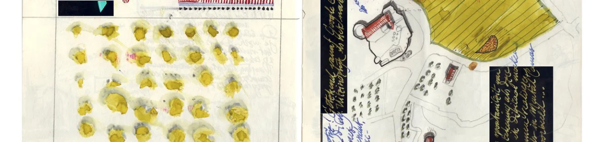
During walks, interviews with people, reading books on the history of the different places, and research in the local library, I take visual and written notes in sketchbooks.
That way I can process the amount of information and retrieve it more easily afterwards. In addition, the drawn notes are already an exercise in displaying the information later on in a more definitive stage. But, like the project itself, they are alive, evolving, and probably never ‘finished’.
I’m not sure where this experiment will lead me, but I hope you tag along!
Update: for more details on the different locations, please read the Oppède-le-Vieux to Sénanque post.
Interesting links on deep mapping
A deep map, or spatial narrative, is in practice a complex layering of different sorts of media and content like texts, photographs, video and drawings.
For those interested in deep mapping, these are a few interesting links:
1
A deep map approach can help towards a fuller understanding of the impact of place on society through the many overlapping layers of interaction across time.
http://deepmappingsanctuaries.org/
2
“The deep map recognises the slippery identity of place, and seeks to visualise the multiple identities that go towards constructing the human experience of place.” (Anon 2015 – Geospatial Humanities website
http://wp.lancs.ac.uk/lakesdeepmap/the-project/gis-deep-mapping/
3
The term deep map references the gathering and selection of mixed materials during embodied field and archival research developed by Mike Pearson, Michael Shanks and Clifford McLucas after being inspired by William Least Heat-Moon’s deep map of Chase County, Kansas.